1

The great probability of a North West Passage deduced from observations on the letter of Admiral de Fonte — Inside the Classic
(0 User reviews)
1425
Project Gutenberg
2015
Not confirmed
Labrador (N.L.) -- Discovery and exploration; Northwest Passage -- Discovery and exploration; Discoveries in geography -- Spanish; Fuentes, Bartolomé de, active 17th century
Readers of public-domain and historical texts
Project Gutenberg digital edition
en
Edition facts
Words
70,484
Reading time
307 min
Text sections
14
The source record for The great probability of a North West Passage deduced from observations on the letter of Admiral de Fonte — Inside the Classic measures this digital text at 70,484 words, 5 hr 7 min estimated reading time, and 14 detected text sections.
The text analysis averages about 37.0 words per sentence, while the detected sections provide another way to judge how the source is divided.
Project Gutenberg metadata also associates the work with “Labrador (N.L.) -- Discovery and exploration,” connecting these edition facts with the source record’s subject description.
Source:
Project Gutenberg record #48528
An 18th-century geographical treatise arguing for a Northwest Passage through analysis of Admiral de Fonte's letter, Spanish maps, and Hudson's Bay voyages, with an appendix on Labrador.
Editorial Edition Score
4.8/5
★★★★★
★★★★★
Calculated from edition completeness, EPUB availability, text structure and catalogue metadata. Not a user rating.
How this score is calculated
- Description quality20 pts
- Title & short description10 pts
- Source metadata20 pts
- Text length15 pts
- Chapters / structure15 pts
- EPUB file integrity20 pts
Total of 100 points, scaled to a 2.5-5.0 range. Editions with an empty description or a missing EPUB file are not scored.
Edition quality
Public-domain source text
Read the source text
The source text is kept in the dedicated reader, separate from this catalogue record and its commentary.
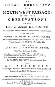
The work opens not with a narrative but with a dense title page that frames the entire project: a deduction of the great probability of a Northwest Passage from observations on a letter by Admiral de Fonte. The title itself is a miniature argument, listing three maps—a Spanish map of 1608, Captain Smith's discoveries in Hudson's Bay (1746–1747), and a general map of de Fonte's discoveries—as evidence. The author, Thomas Jefferys, geographer to the King, immediately establishes a method of cross-referencing cartographic and textual sources. The dedication to the Earl of Hillsborough further signals the work's political and commercial ambitions, linking the passage to national glory and trade.
The Letter as a Puzzle
The core of the argument is the letter of Admiral de Fonte, which the author treats as a document to be decoded rather than a straightforward account. The text repeatedly returns to specific coordinates and courses: de Fonte sailed from the Island Basset northeast, entered the Tartarian Sea in latitude 61, then steered 140 leagues east-northeast. The author corrects what he calls “Mistakes in the Publication in April,” noting that the land trending northeast was misreported. This attention to navigational detail—latitude 63°39′, longitude 110° from London—reveals a methodical, almost forensic approach to the letter. The reader is drawn into a world where degrees and minutes are clues, and where a single misstated bearing can unravel or confirm a theory.
Mountains, Ice, and the Shape of the Coast
Landscape features are not merely described but interpreted as evidence. When de Fonte’s seaman reports that Baffin’s Bay terminates in a lake of about thirty miles in circumference, with “prodigious Mountains” to the north, the author seizes on this as proof of a closed basin. The ice lying “a great Distance out” is consistent, he argues, with there being no inlets—waters from inlets would have set the ice off. The high mountains imply a more level country where the view was taken. This reasoning is typical of the work: physical geography is read for its implications about hidden passages. The journey of the Indian and sailor, estimated at fifty miles, is deemed “practicable” even by land, and easier if partly by water. The author’s confidence in such inferences is striking.
Labrador: A Counterpoint to Hudson’s Bay
In the appendix, the focus shifts to Labrador, a region the author contrasts with Hudson’s Bay. He observes that places in the same latitude do not have equal heat or cold; Labrador, in latitude 56, is “capable of being improved by Agriculture” despite rugged mountains. The winter is less severe than in more southern parts of Hudson’s Bay—the earth does not freeze there as it does around the bay. People have wintered in Labrador wearing only their usual clothing. This section serves as a practical counterweight to the theoretical arguments about de Fonte. It grounds the debate in the actual conditions of North America, suggesting that the passage, if found, would lead to habitable lands. The author’s tone becomes more empirical, drawing on recent experience rather than old letters.
Maps as Arguments
The three maps listed on the title page are not illustrations but evidence. The author refers to a Japanese map brought over by Kemper, which shows a branch of the Tartarian Sea extending southward, agreeing with de Fonte’s account. The Spanish map of 1608 is treated as an authentic source, and Captain Smith’s discoveries in Hudson’s Bay (1746–1747) provide recent data. The work is structured around these visual documents: the reader is expected to consult them while reading. The author’s method is comparative—he places de Fonte’s narrative alongside Russian discoveries and Japanese cartography to show consistency. The maps are not decorative; they are the scaffolding of the argument. Without them, the text would lose its evidentiary foundation.
This is a work that demands active reading. The author expects the reader to follow navigational calculations, compare maps, and weigh the credibility of sources. The excerpts reveal a mind that treats every detail—a bearing, a mountain range, a patch of ice—as part of a larger puzzle. For those interested in the history of exploration or eighteenth-century geographical reasoning, the book offers a case study in how evidence was assembled and contested. Approach it as a detective story, not a travelogue.
There’s something tender about old arguments for what wasn’t there—the Northwest Passage, always just beyond the maps. I found myself thinking of that same hopeful stubbornness in The Voyages of Pedro Fernandez de Quiros, 1595 to 1606. Volume 1 — Inside the Classic, another dreamer chasing a southern continent that kept slipping away. Both books feel like letters to a future that never quite arrived, and I’m glad they’re still here.
There are no reviews for this eBook.
There are no comments for this eBook.
Reader reflection
Record your reading impressions
A brief reflection can help important ideas stay with you longer.
Your progress
0
/
10
2
Did this book hold your interest?
3
Would you pass this book on to a friend?
4
What was the reading difficulty like?
5
Was the book what you thought it would be?
6
What did you appreciate most?
7
Was the book easy to understand?
8
Did the story or argument move comfortably?
9
What is the main idea you are taking away?
10